Whether it is a shopping mall, airport, hospital, hotel, or any large building with multiple shops inside the building, you need a real-time reference point of a location to track user devices, assess foot traffic, or provide the exact route to ridesharing companies. These reference points are nothing but polygons, i.e., the property boundary of the building where it is situated.
Xtract.io handcrafts polygons, whether it is a stand-alone building or a shop inside a mall. All of this with 95% accuracy, quick turnaround time, and flexible deliverable format of your choice.
Currently, Xtract.io has manually drawn 1 million polygons for retail and accommodation places, food stores, malls, airports, heliports, ferry terminals, park & ride locations, and many more. These powerful polygons help in creating accurate indoor maps that aid businesses in various ways.
What is indoor mapping?
Indoor mapping is a process of transforming physical spaces into digital maps that provides us with an interactive representation of the location. It helps in improving customer experience by analyzing the footfall of a store or a mall. This type of technology enables businesses in identifying the positioning of the user, device, or other assets. For example, a shopping mall can leverage indoor positioning technology to understand which part of the mall is performing well from customer foot traffic per se. It can answer many pressing business questions such as –
- Which part of the mall is usually crowded?
- Which products are most customer-centric and top-selling?
- How to position products based on the crowd in a specific portion of the mall?
Through indoor mapping solutions, such questions can be easily answered and an in-depth analysis of market strategy can be performed.
How are indoor maps created?
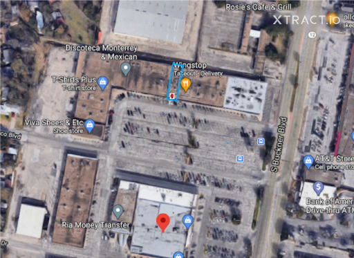
Indoor maps are created using accurate polygon data. Polygons, as mentioned above, are property boundaries of the building, i.e., the x and y coordinates of the building. Using aerial imagery, polygons are manually drawn via GIS application. These polygons are then shared with businesses that rely on spatial data visualization to make geographically-driven decisions. For example, the below red-marked area indicates “Wingstop” restaurant located within “Pleasant Groove Shopping, Center, Texas, U.S”. This polygon is manually drawn and verified by Xtract.io.
Top 3 benefits of using indoor mapping technology
- Locating sales hotspots
For retailers, sales is their bread and butter. The retail industry comprises grocery stores, supermarkets, restaurants, toy shops, bookstores, clothing showrooms, shopping malls, etc. In the US, there are around 4 million retail stores, and the total retail sales in the country increased from 5.4 million USD (in 2018) to 6.03 trillion USD (in 2022).
Despite the country not being the home of shopping malls, it was one of the key players to generate the highest per capita retail sales via shopping centers, The primary reason for this spike is that Americans still continue to shop at malls, instead of online shopping. Malls are a convenient way to visit and shop from multiple retailers, making it a one-stop shopping experience.
Therefore, retailers need to leverage this foot traffic and convert it to good sales because for every online order made by the consumer, it is a loss for retailers. The retail industry can utilize polygon data to create floor plans of the malls to understand which competitor is performing better, which brand is popular among different age groups (kids, adults, etc.), and the impact of the location of the shop inside a mall.
For example, an accurate indoor map could show us that the foot traffic near the entrance of the mall is much higher, compared to shops on the top floors. Other parameters that can be analyzed via indoor maps are – the time spent by a customer in a specific shop inside a mall, the frequency of the visitor, and many more that could add value to enrich the customer experience.
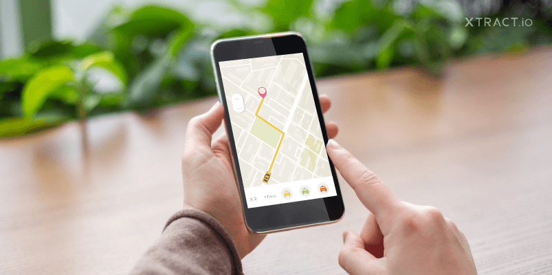
- Measuring the fastest route
Imagine a ride-hailing company uses inaccurate, obsolete location data. The impact of this data could be too much time taken to pick up or drop a customer, taking longer routes to reach a location, unable to spot the right location to reach, multiple calls to the customer for the right location spot, and this cancellation of the ride itself. This leads to poor customer service. Similar events happen with food delivery companies, ecommerce brands, and other digital businesses that are involved in the delivery of products or services.
Therefore, the quick pick-up and drop feature is the USP of every ecommerce brand and ride-hailing company. With the right, accurate, latest, and real-time location data, companies can satisfy consumer needs. For example, with the right location data, a food delivery company can deliver the food to the right customer at the right time. What more does a hungry consumer needs? A fulfilling and perfect customer service!
- Improving wayfinding and operational efficiency
If your guest in the hotel forgot her way to the pool, does she have to go back to her room to get the hotel floor map? No, this is an additional effort and a waste of time for the guest leaving a bad impression about the hotel. Therefore, the travel and tourism industry must make the most use of indoor maps to help their guests have a comfortable stay and experience with the help of location data.
Wayfinding is crucial in public places such as museums, exhibitions, hotels, theme parks, casinos, cruise ships, and many more. It can also help the travel companies to identify the most crowded sightseeing spot, the most popular place in the nearby location, and many more to plan the tour of the guest accordingly. Location data helps the tourism industry to improve city infrastructure, enhance tourist spots and activate marketing campaigns based on public likes and dislikes. With the right polygon data, accurate indoor mapping technology can be leveraged by the travel-tourism industry from POI database.
Indoor mapping technology is the future of the business to drive maximum sales and bring in more customer engagement. Therefore, it is the right time to join the bandwagon and leverage the powerful capabilities of POI and location data to drive your business forward. At Xtract.io, we help you to visualize the real-time location digitally through our accurate and handcrafted polygon datasets. Connect with us for a quick demo, if you want to make the next right move to scale in your business.