With demand for location-driven decision-making needs and increased use of interactive maps, businesses, organizations, and government sectors leverage location analytics to make informed business decisions. To take a geographically driven decision, the right location data is the key element. Location data and its various data types play a vital role in the location industry.
What is location data?
Location data refers to geographic information of an object, building, or a human in a specific geographical space or horizon. Location data consists of various attributes such as an address, country, state, boundary of the location (polygons), and places data such as if the place has a parking facility, ATM, or if it is pet-friendly. While there are a plethora of location data types, a few of the important ones are discussed in this blog.
POI data
POI, also known as points-of-interest data covers a wide range of data points such as the address of the location, email, contact details of the location owner (store or residential), the business name, latitude and longitude of the location, and many more. View and download a free sample of POI data across various industries such as retail stores, healthcare centers, banks, ATMs, etc. from Xtract.io, a leading location data provider.
This information helps businesses in understanding the market, competitors, and consumer behavior. Geomarketing and site selections are primary use cases of POI data. For example, a bank can decide to open a new ATM center based on the financial transactions that occur per day in a specific locality. To optimize site selection decisions, location data plays a vital role.
Polygon data
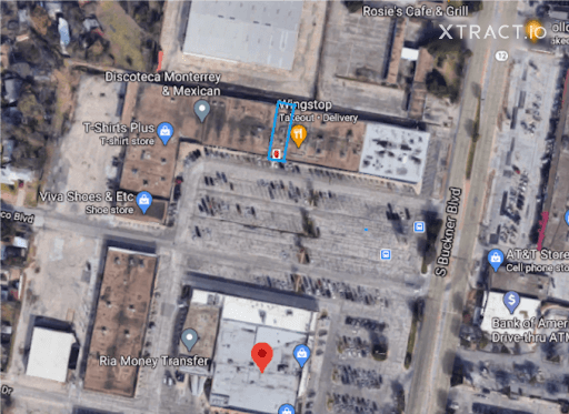
Polygon data indicates the boundary of a building, store, or any location. For example, the polygon data of a restaurant named “Wingstop” in the US is indicated in the screenshot below. Created by Xtract.io, the boundary of the restaurant is marked in blue.
Using this data, a geofence can be created around the restaurant and push-up notifications such as offers, discount messages can be triggered to the customers who are in close proximity to the restaurant. This is known as location-based marketing or geomarketing. Such type of information drives customers, boosts engagement, and increases sales and revenue.
Foot traffic & mobility data
While a lot of marketing strategies can be executed, but the result of it is to determine how many customers visited the store. This information is known as foot traffic data or footfall at a store, i.e., the number of people visited in and around your store. For retailers, foot traffic is a key barometer as it answers a lot of important questions such as –
- How many people walked into your store at different times of the day?
- How many people walked near your store and passed by (known as geofence data)?
- How long did they stay at your store (known as dwell time)?
- Which part of the store customers get stuck and walk off in a few seconds (known as friction points)
- Where do your customers stay for long? Which sections grab their attention and why? (known as clusters)
An array of such information, derived from footfall, help retailers to understand their store visit, strengthen their marketing efforts and build customer relationships.
Demographics data
The spatial dataset includes demographic data such as population, income, gender, education, employment rate, etc., of a specific geographic location. This type of data helps businesses and the government sector to detect patterns, identify trends in a location to take a successful decision.
Demographic data has played a vital role during the Covid pandemic. Government sectors and health centers identified the hotspots of the viral infections, tracked them to provide necessary health treatments. It also helped to manage the inflow of the patients and prevent the widespread of this zoonotic illness.
Road traffic data
In the LI sphere, road traffic data provides organizations with information on human mobility patterns, road network performance, speed and travel time of automobiles, etc. This information aids various industries such as real estate, retail, government, logistic players in the market to unlock insights for their respective businesses.
Using road traffic data, the government can determine accident-prone locations, analyze and plan city infrastructure accordingly to improve road safety and protect the localities. Similarly, supply chain and food delivery businesses can leverage this data by identifying the most optimal route to avoid road traffic and serve the customer on time, with ease.
Conclusion
Technology advancements have made the ability to capture location data easier and feasible. At Xtract.io, location data are captured with 95% accuracy and upgraded on monthly basis. Get access to 5 million location data across the world and supercharge your business operations. Connect with us now.