Did you know that a recent study ranked location intelligence only 12th out of the top 25 technology trends and priorities? What does this mean? Maybe the technology is new and complicated to the audience, or it is overwhelming the industry in its operations, and everybody may seem like…

However, since location intelligence is setting its footprints in almost every industry, there’s no denying that it has become the new frontier for data-driven business. We have seen ample use cases and benefits of location intelligence in prominent industries such as retail, automotive, restaurant, and many more. In this blog, we will see the new role of location intelligence in sustainability and green initiatives. Before diving deeper into the topic, let’s get to know more about location intelligence.
What is location intelligence?
Location Intelligence is an intuitive methodology that provides business insights using geographic and geospatial data. These data include:
- Geocoding data
- POI or points-of-interest data
- Physical addresses
- Latitude and Longitude
- Postal code
- Aerial maps
Apart from these data types, location intelligence comprises different data types that businesses use in their analytics. The use of location intelligence has become a necessity of every business as it helps them to make a strategic decision upon understanding the consumer and competitive landscape in detail. The core benefits of adopting location analytics and intelligence in any business are Geomarketing, Competitive intelligence, and Site Selection.
5 popular green initiatives using location intelligence
The impact of growing industrialization and urbanization on planet earth is severe. As a result, the world now faces bad climatic conditions, unanticipated natural disasters, and many more. However, global technological developments are rapidly contributing to make the world a better place to live. Today, government organizations, environmental activists and groups, and technology companies use location intelligence to save the planet. Let us take a closer look at the five popular green drives that use geospatial data.
1. Sustainable agriculture
Agriculture plays a significant role in causing environmental changes such as climate changes, deforestation, water scarcity, land debasement, and many more. Sustainable agriculture ensures to perform mindful cultivation that fulfills the needs of the population and saves resources for upcoming generations.
Using location intelligence, the agricultural land is analyzed based on its site location and surrounding areas, and sustainable farming methodologies are adopted for better yield. It also helps businesses in this space to control their inventory network, which is spanned across places.

Another important use case of location intelligence in sustainable development is locating naturally powered energy farms. As you know, the sun and wind are the two most natural and purest forms of energy. It is a herculean task to locate the ideal location to build sun-powered and wind-energy farms. Location intelligence helps in finding the right location and supports in the pre-development stages of building such naturally powered farms. This technology makes it easier to identify the locales of generators, substations, warehouses, and other related inventories.
2. EV charging stations over harmful emissions
The global electric vehicle market has significantly matured over the last decade. Compared to 2019, the sales of electric vehicles grew by 43% in the first half of 2020, post which the market observed a dull moment due to the pandemic. However, it came back stronger in 2021, breaking the sales record for electric vehicles to 6.75 million, which is doubled from the previous year.
With a zero emissions target by 2050, the EV industry is clearly gearing up to complete its successful ambition. Using location intelligence, recognizing the right place to set up these EV stations is easier and ensures the city is cleaner and greener. It helps towns and cities with maps to understand the population density, closeness to focal points, and segment data to ensure that the EV station is out up at the right place.
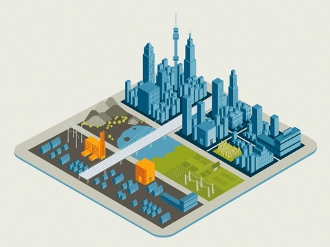
Smarter and greener cities
The real estate market is booming, and location data has been assisting realtors in building a safe and smart city for people to live in. Location intelligence assists city designers in designing protection projects and building greener spaces around the city. Through geospatial data, network planning models and infrastructure investments are made accurately, which is driven to make an economical and sustainable city.
Using location intelligence, road and traffic management can be monitored to reduce harmful emissions through vehicles; transport systems, public hotspots, and energy plants can be positioned upon gaining better insights to develop its expansion models.
4. Faster healthcare during natural disasters
We all know how covid has impacted the world. It shook every business life of the common man and impacted severely. However, location data aided the government and other organizations in many ways to combat this zoonotic disease.
Similarly, location data can provide insights into the number of cases in a particular location, its nearest recovery camp, etc., to provide faster healthcare to the localities. Location intelligence assists the government sector in such catastrophic disasters to control and provide a safer environment to the public. Additionally, this technology helps to understand air quality in a specified location, pollutant percentage, etc., so that stores and buildings are constructed accordingly. It helps in choosing the right place before development and planning accurate strategies after development.
5. Sustainable transportation routes
Location intelligence helps government officials and administrators to research, study, and proceed with project plans on where to foster bike rides and other racing events. This will diminish the air pollution in the main hub of the location and reduce traffic congestion.
Spatial examination indicates the best centralization of where each individual is and where the bike courses and offers must be situated for better audience engagement and feedback. This includes ingesting geospatial information and working with other data sources to build greener strategies that drive healthier experiences.
With growing urbanization, any green drive, big or small, is a ray of hope to build a better planet. Xtract.io, a location data provider, strongly believes in and supports this initiative. Our POI database consists of 6 million POI data that can help you with your green initiatives. Join us today and learn how.