Cities these days are no longer just collections of streets, buildings, and landmarks. They’re dynamic systems. Why, because they are shaped by human activity that is constantly shifting with time, movement, and behavior. Latitude and longitude coordinates alone don’t turn a static map into a living model. It’s the POI attributes, like operating hours, amenities, and reviews, that are attached to each point of interest (POI) that make a map useful. In other words, POI attributes include location details and dynamic information that make a place more than just a point on the map. These POI attributes are leveraged by businesses for geospatial analytics to gain deeper insights and accelerate decision-making processes.
Retail industries, restaurants, and service providers rely on geospatial analytics to reveal competitive strengths, customer behavior patterns, and demand shifts. These insights help businesses decide where to open their next store, how to market, and when to allocate resources.
We’ll walk through the key attributes of POI data, why they make a difference, and share practical examples of how organizations are using them to drive results.
Not sure what POI data is all about? Here is a simplified guide.
What are the types of POI attributes?
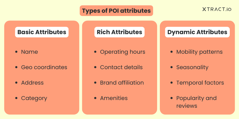
POI attributes usually fall into three main types. Each type adds a different layer of detail that turns a simple point on a map into something far more useful for geospatial analytics.

1. Basic attributes: These are the essential location details that put a place on the map. They include the name of the location, its address, its latitude and longitude coordinates, and the category it belongs to.
2. Rich attributes: These POI attributes add more value to the basic attributes by adding personality and context. They provide in-depth insights to businesses, informing them whether a place stays open late, is part of a chain, offers Wi-Fi, or includes contact details.
3. Dynamic attributes: These POI attributes reflect how a place’s characteristics change over time, such as peak visiting hours, seasonal changes, or special events.
Now that we understand the different types, let’s explore them in detail.
What are basic POI attributes?
Core POI (Point of Interest) attributes are the must-have location details that define and identify a place. They drive business decisions by providing value through competitive insights and market analysis. They also help people find locations, explore nearby services, or simplify navigation, supporting their everyday needs.
Name – What defines a business’s identity?
Names are the primary location details that distinguish one shop or a POI from another. By knowing competitor names, a business can track where they are located, how many exist in a specific area, and determine their market share.
Latitude and longitude coordinates – Where exactly is it?
Coordinates provide the precise geographic location of a place on the map and serve as a fundamental element in geospatial analytics for analyzing spatial relationships. They also help define the boundaries of a place, indicating where it starts and ends. Boundaries are useful for mapping delivery zones, planning service areas, guiding navigation, and differentiating nearby places.
Address – How do you get there?
These location details enable efficient delivery, shipping, and supply chain operations. They also help businesses analyze accurate geographic density and proximity of their competitors to decide where to place new outlets.
Category – What kind of place is it?
The category describes the type of business or service a location offers, helping businesses quickly understand what to expect without having to guess. It enables them to analyze market saturation, identify customer-frequented places, and pinpoint gaps in services within an area.
What are rich POI attributes?
The basics tell you a place exists, but rich attributes are location details that tell you what that place is really like. They add personality, context, and usability to the POI data for better geospatial analytics.
Operating hours – When is the place actually open or closed?
Knowing when competitors are open or closed for business helps businesses plan staff schedules, identify when competitors are busiest, run targeted promotions, and make better decisions based on real customer patterns.
Brand affiliation – Is it independent or part of a larger network?
This location detail helps businesses understand the competitive environment better. Chains may bring strong brand recognition and resources, while small businesses often offer unique, local experiences. It enables smarter decisions around investment, pricing strategies, and market positioning.
Contact details – How do businesses connect with the place?
Contact details, like phone numbers, websites, and social links, make it easier for businesses to reach out for partnerships or sales. They also reveal how competitors engage with customers through reviews, comments, and likes, helping brands compare strategies and find new opportunities.
Amenities – What features does the place offer?
Amenities describe the extra features or services a place provides, like Wi-Fi, parking, or outdoor seating. They help businesses highlight their unique value proposition, attract the right customers, and compare offerings with competitors to identify what drives the best customer experiences.
What are dynamic POI attributes?
A POI might stay in one location, but the way people use these POI attributes keeps changing, and these changes are called dynamic POI attributes. They show us patterns and trends based on real-time activities.
Mobility patterns – How and when do people visit?
Mobility patterns describe how and when people typically visit a place, such as peak hours or popular days of the week. These patterns can be understood through location details like operating hours, review timestamps, and customer feedback. For businesses, this insight supports better planning, service adjustments, and competitive benchmarking.
Seasonality – When is the place most popular?
Seasonality can be revealed by looking at month-over-month activity, weather impacts, seasonal search trends, and transaction data. For example, an ice cream shop may see more activity in summer, while a ski resort peaks in winter. Combining these attributes helps businesses understand when demand is naturally higher or lower.
Temporal factors – Are there special days that change usage?
Temporal factors capture special days or events that affect how a place is used, such as holidays, festivals, or local events. POI details like competitor holiday schedules, sudden traffic surges, and temporary closures help businesses anticipate shifts in demand, prepare accordingly, and align their strategies for these key events.
Popularity and reviews – How do people perceive the place?
Popularity and reviews show how people experience a place and how that perception evolves. By following ratings, sentiment, and feedback volume, businesses can identify areas where quality has improved, where frustrations persist, and where they can offer better solutions than competitors.
What are the benefits of POI attributes for different industries?
Across industries, distinct POI attributes are applied in varying ways to support decision-making through geospatial analysis.
Retail and real estate
POI attributes such as neighbourhood businesses, reviews by customers, and shopping patterns, reveal where people are most likely to visit brands. These insights can help businesses choose the best store locations, run smarter campaigns, and adjust amenities to match customer needs.
Logistics
Companies plan deliveries by using POI details like store hours, busy times, and delivery access points. Store hours make it clear when a location is open, preventing wasted trips and late deliveries. Busy times highlight when traffic or crowds might slow things down. Access points reveal if a location is hard to reach, helping avoid wasted time and effort.
Urban planning
People form patterns as they move, gather, and use different services, shaping POI attributes so that they reveal how places are used. In geospatial analytics, these attributes help urban planners identify crowded areas, neglected neighborhoods, and popular hubs, ensuring that parks, clinics, and transit stops are built where they’ll be both needed and well-utilized.
Navigation apps
Apps understand which places are popular, when they’re least crowded, and what experiences they offer with attributes such as ratings, busy times, and opening hours. Not only do they know the places, but they are also capable of suggesting the quickest routes and the best places to eat, shop, or explore, improving customer experiences.
Final thoughts
POI attributes, as we saw, are all about turning static location details into intelligent, living models through the process of geospatial analytics, to uncover patterns and insights. With such detailed information about a location, businesses can gain predictive insights, identify opportunities, and make smarter decisions with real-time data.
Looking for POI data with over 40 POI attributes? Let’s talk!
FAQs
1. What are POI attributes?
POI attributes are a combination of basic, rich, and dynamic location details about a POI, such as its name, category, opening hours, amenities, and usage patterns. They also reveal the dynamic trends of each POI, turning simple map points into meaningful insights.
2. Why are dynamic POI attributes important?
If we look into trends, shifting seasons, and events, they show how people engage with a location. This helps businesses and planners estimate demand and make better decisions.
3. How are POI attributes helping businesses?
Businesses can use geospatial analytics with POI data to identify their local competitors, understand which spots people visit frequently, and determine what customers care about most. This makes it easier to spot trends, choose the right location, get more out of marketing, and give customers a better experience.
4. Can location details help city planning?
Yes. City planners use location details to identify where essential services like schools, hospitals, or transit stops are located, ensuring balanced access across the city.
5. How do apps like Google Maps or Uber benefit from POI attributes?
Google Maps uses ratings, categories, and amenities to recommend the most relevant stops. Uber uses peak times, operating hours, and other POI attributes to suggest the quickest routes.
6. How do retail or real estate companies benefit from POI attributes?
Retail companies use POI attributes like customer behavior patterns, popular trends, and nearby points of interest to choose store locations, plan promotions, and enhance sales. Real estate companies use POI attributes to evaluate property surroundings, analyze local competitors, and make informed decisions about investments and development opportunities.


